Byron
Paddler
In searching the archives for trip reports for the Bella Coola area, I was surprised not to find any. So here's some pictures of our trip last summer. If anyone else has ventured into the area feel free to post as well.
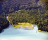
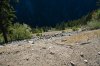
Driving in one eventually has to descend from the Chilcotin Plateau into the valley via "The Hill". It's a gravel road with multiple switchbacks glued to the side of the mountain. Here's a picture looking over the edge. Note the white car far below.
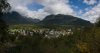
The town itself looks like this.
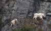
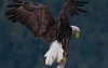
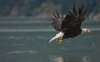
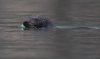
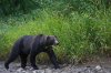
Lot's of wildlife. On the mountains.
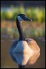
Or from the water.
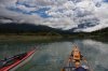
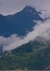
Plenty of places to explore
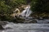
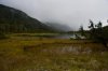
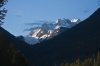
Great scenery
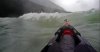
And always afternoon winds (I'm dead ahead about 20 feet and there's a double just to my left...both invisible...although my friend scored points for trying to get a picture with waves towering above eye level.)
Not really for beginners as takeout spots are sparse and limited with fierce afternoon winds. You'll often find yourself going the wrong way down the channel and not by choice. The inlet is long, narrow and deep. The mountains are high, vertical, dropping straight into the sea. When the native name for an area of water is "Dancing Waters" or "Devils Nose" and the best sheltered location you can find is called "Windy Bay" one is wise to expect trouble!
All in all, great kayaking especially if you like the wild west coast and are prepared to put on some miles.
Driving in one eventually has to descend from the Chilcotin Plateau into the valley via "The Hill". It's a gravel road with multiple switchbacks glued to the side of the mountain. Here's a picture looking over the edge. Note the white car far below.
The town itself looks like this.
Lot's of wildlife. On the mountains.
Or from the water.
Plenty of places to explore
Great scenery
And always afternoon winds (I'm dead ahead about 20 feet and there's a double just to my left...both invisible...although my friend scored points for trying to get a picture with waves towering above eye level.)
Not really for beginners as takeout spots are sparse and limited with fierce afternoon winds. You'll often find yourself going the wrong way down the channel and not by choice. The inlet is long, narrow and deep. The mountains are high, vertical, dropping straight into the sea. When the native name for an area of water is "Dancing Waters" or "Devils Nose" and the best sheltered location you can find is called "Windy Bay" one is wise to expect trouble!
All in all, great kayaking especially if you like the wild west coast and are prepared to put on some miles.
Attachments
-
 IMG_1882.jpg194.7 KB · Views: 3,354
 -
 BellaCoola_Townsite_Panorama.jpg88.3 KB · Views: 3,351
 -
 MountainGoats_BellaCoola_Fullzoom_9508.jpg116.5 KB · Views: 3,297
 -
 IMG_1361.jpg58.9 KB · Views: 3,313
 -
 IMG_1382.jpg49.9 KB · Views: 3,331
 -
 IMG_1101.jpg46.6 KB · Views: 3,373
 -
 IMG_1110.jpg194.8 KB · Views: 3,343
 -
 Goose_7733.jpg134.8 KB · Views: 3,329
 -
 IMG_1437.jpg103.5 KB · Views: 3,342
 -
 IMG_1489.jpg145.7 KB · Views: 3,321
 -
 IMG_1470.jpg100.6 KB · Views: 3,358
 -
 IMG_1613.jpg58.3 KB · Views: 3,314
 -
 IMG_0927.jpg74.7 KB · Views: 3,340
 -
 OceanWave.jpg63.6 KB · Views: 3,394