• We apologize for the somewhat convoluted sign-up process. Due to ever-more sophisticated attacks by chatbots, we had to increase our filtering in order to weed out AI while letting humans through. It's a nuisance, but a necessary one in order to keep the level of discourse on the forums authentic and useful. From the actual humans using WCP, thanks for your understanding!

Hotham Sound Campsite Information Needed

I’m looking for some information about the Hotham sound campsite. I have someone with limited mobility of their legs, but they are active, fit and very comfortable in and around water.

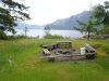
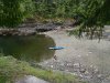
Could someone provide a picture of the beach, and a description of the walk up to the campsite from the beach? A photo of the campsite would also be useful.

Would the campsite be flat/smooth enough to get around on a wheelchair?

I am to understand that there are no pit toilets, is this still correct?

Would any of the other nearby campsites be a better option? We would be launching from Egmont and I’m looking at campsites a short day paddle from there.

Thanks,
Alana
 
Ok so after asking around I have realized that the campsite at Hotham sound isn't suitable for my groups needs.

Does anyone have information on Goliath Bay? It's in Jervis Inlet, between Hotham Sound and the Prince of Wales Reach.

This is described as a rock beach, with a small upland area. Would this be suitable for 3, possibly 4, small (2 person) tents? Is the beach smooth enough to camp on at a lower tide?

Thanks,
Alana
 
Alana,

I camped in Goliath once a few years back. I just went looking for pix but can't seem to find any so you'll have to rely on my memory. We paddled around a bit looking for the camp that you describe and never found a clear upland, my guess is that it was a log dump that is now overgrown. We did find a place to camp on the beach, I can't remember how much levelling we had to do but I think it was pretty straightforward. We were there in May and there was a creek feeding into the bay, C even took a quick bath in a pothole. The beach is a typical rocky one, and if I'm remembering correctly at low tide there's an oyster bed that might make travel difficult for someone with limited mobility, though i could be getting that mixed up with another spot. I think there would be ample room for a couple tents and probably up to 4 if you don't mind crowding.

As I'm typing this I seem to remember That there was an old concrete slab on the berm above where we camped and if you didn't mind sleeping on that you could definitely fit 4 tents.

Sorry I'm not more help, wish I could find the pix!

Speaking of which, getting back to Hotham, here's some pix from camping next to Harmony falls. I'm not sure if this is the site you were asking about but it seemed to be the obvious spot to camp.

camp.JPG


As you can see it's a tiny beach, there would be room for two tents, maybe more. The view is good,

view.JPG


and I think it'd be fine for your friend with mobility issues as the beach is mostly pebbles and fairly short from water to Forest.

Then one last option might be Fairview bay. That's on the Sunshine Coast Trail and has a hut. http://www.sunshinecoast-trail.com/fairviewbay.html It might be a bit difficult getting up to the hut but the flat area around the hut should be fine for a wheelchair.

Hope this helps

Rog
 
Last edited by a moderator:
Here's a picture of the same Hotham Sound campsite facing the opposite direction. I agree with Pryaker, it's the obvious one in the immediate area and I don't think any come easier from a mobility viewpoint. Alana, if that is the campsite you are referring to, I'm curious what info/criteria suggests it is unsuitable?

IMG_4296.jpg
 
Last edited by a moderator:
There's a campsite on the west side of Hotham Sound, almost directly across from the falls that has a nice pebble beach and is an established campground used by kayak touring companies. It has the best beach access of all the sites I'm aware of in Hotham plus a beautiful view up the sound. Not sure of the exact GPS coordinates but PM me and I can send them. It has a short trail from the beach to the campsite, nothing strenuous.
 
The campsite in Hotham Sound that I'm talking about is at N49°51.15' W124°00.17'. I was told that it is way too small for 4 tents, and that it was camping on a rock shelf, which would be too difficult for my friend to get to. I'm referencing The Wild Coast Volume 3 and that is the only campsite in Hotham sound shown. I would love to get the coordinates for any other recommend campsites.

The campsite at Goliath Bay is shown at N49°50.34' W123°56.55'. Judging by Google earth, this appears to have a larger beach, however I don't know how much of it is tidal. I called the Backeddy in Egmont and although the person that I talked to didn't know much about Goliath, she said that they were going to look into it for me.
 
The pictures pryaker and I posted are of the campsite shown in John's book. I have the coordinates at: N49 51.084 W124 00.136. You can see from the pictures that it is NOT rock ledge camping! However it is susceptible to high tide and the available tent area above the high tide line is indeed small. Two tents would be easy, I think four tents would be tight but doable if you're motivated enough and the high tide not too excessive. For example, we pitched our 3 man tent in this spot beside the hammock (on the leaves)...there was room to spare...if you put 2 small tents there then you are halfway done.

There is also this site about 3kms further south (south of Granville Bay). It may not be suitable for your friend due to the required rock ledge dismount but the upland grassy camping area is large and will hold 4 tents easily:

IMG_4252.jpg

[admin: named as 'Mt Foley' and located at 49° 49.452'N 124° 0.042'W]

There is also Granville Bay itself. I don't have pictures but it has easy access and sufficient area for 4 tents. The logging operation was dormant when we were there in 2011, I don't know current status. The BackEddy could probably tell you.

There is also this area about 200-300m north of the Harmony Islands. Pebble beach with camping in a cleared area in the trees. I can't recall clearly but remember it being large enough for 4 tents. The north end of the beach has a cold stream running (even in August) so the water for swimming was a couple degrees cooler than everywhere else (and warm water swimming is one of the reason to go to Hotham Sound so we avoided it!).

KC2_IMG_4284.jpg

[admin edit: called Syrens Melody located at 49° 52.304'N 124° 1.117'W]

There is a fifth area large enough for a couple tents but too small for four and definitely rock ledge access so I won't include it. However if your party had to split up it is only about 600m from the Harmony Islands.

Anyway, that's my input. Perhaps others can comment (agree/disagree) from their perspective. If you want more info feel free to PM me. Good luck.
 

Attachments

  • KC4_IMG_4443.jpg
    KC4_IMG_4443.jpg
    243.3 KB · Views: 1,322
  • KC4_IMG_4443.jpg
    KC4_IMG_4443.jpg
    243.3 KB · Views: 1,281
  • IMG_4252.jpg
    IMG_4252.jpg
    180.1 KB · Views: 1,281
  • KC2_IMG_4284.jpg
    KC2_IMG_4284.jpg
    211.5 KB · Views: 1,291
Last edited by a moderator:
Here's a shot from the water of the west side landing, and the campsite itself. The last photo is the beach. There is a short trail up to the campsite but from what I remember, it isn't difficult at all.
hotham b-day 2013 021.JPG


hotham b-day 2013 023.JPG


hotham b-day 2013 027.JPG


[admin edited to add: location 49° 50.500'N 124° 2.929'W ]
 

Attachments

  • hotham b-day 2013 021.JPG
    hotham b-day 2013 021.JPG
    119.2 KB · Views: 1,226
  • hotham b-day 2013 023.JPG
    hotham b-day 2013 023.JPG
    117.4 KB · Views: 1,243
  • hotham b-day 2013 027.JPG
    hotham b-day 2013 027.JPG
    97.8 KB · Views: 1,244
Last edited by a moderator:
Steven sent them to me by PM. N49 51.481 W124 03.297

That looks like a lovely beach and campsite. I'm having a meeting with my group tonight and we will discuss our options.

Thank you everyone for your input, I really appreciate it! :clap:
 
So we had our meeting. Unfortunately the person with limited mobility decided that they won't be joining us. We have decided that we want to camp around Harmony Falls the first night. We want to move to Goliath Bay for the second night.

Byron said:
There is also this site about 3kms further south (south of Granville Bay). It may not be suitable for your friend due to the required rock ledge dismount but the upland grassy camping area is large and will hold 4 tents easily:

Do you have the coordinates for this campsite?

Byron said:
There is also this area about 200-300m north of the Harmony Islands. Pebble beach with camping in a cleared area in the trees. I can't recall clearly but remember it being large enough for 4 tents. The north end of the beach has a cold stream running (even in August) so the water for swimming was a couple degrees cooler than everywhere else (and warm water swimming is one of the reason to go to Hotham Sound so we avoided it!).

Also for this one.
 
N49 49.449 W124 00.057, and N49 52.308 W124 01.122

If you want to camp or picnic on a tiny island in the Pacific you can try this one at N49 52.319 W124 01.600:

IMG_4531_stitch.jpg


[admin edited to add - called Syren Islet E, see upper left of map and jpg below for more info:]

SyrenIt.jpg


HotmE-SyrenItE.jpg
 
Last edited by a moderator:

kayakwriter

Administrator
Joined
Feb 27, 2006
Messages
1,282
There's a campsite on the west side of Hotham Sound, almost directly across from the falls that has a nice pebble beach and is an established campground used by kayak touring companies. It has the best beach access of all the sites I'm aware of in Hotham plus a beautiful view up the sound. Not sure of the exact GPS coordinates but PM me and I can send them. It has a short trail from the beach to the campsite, nothing strenuous.

Bumping this old thread to ask if anyone has the GPS coordinates for the commercial campsite mentioned above. We're heading up to Hotham Sound end of September. Based on the photos taken from this campsite that show the falls on the other side of the sound and a bit of land blocking the view on the right, the site should be in either the first or the second "pocket" northwest of Elephant Point. But if anyone does have a more specific location for me, that'd be helpful.
 
The commercial campsite 'Elephant Point N' is at
49° 50.500'N 124° 2.929'W

ElephantPt.jpg


ElephantPtN-land.jpg


ElephPtN.JPG


The other sites shown have more difficult landings, are small and have undeveloped camping situations.
Of these others, aside from the rock shelf landing, and 2 or 3 sites, ElephantPtS is a 'king of the world' site:

ElephPtS-land.jpg


ElephPtS-camp1.jpg


ElephPtS-view.jpg
 
Last edited:
[some info as well as images have been added or expanded to other posts above]
**
also:

Goliath Bay [around the corner from Hotham Snd] info was requested above:

location: [at ctr of image] 49° 50.339'N 123° 56.541'W
GoliathBay.jpg


landing:
GoliathBay-landing.jpg


beach camp and small [2 sites] upland camp in grass at far right of image below:

GoliathBay-land2.jpg
 
I see that the OP Alana mentions 'the Hotham Sound campsite' there sure is more than a few. Here's the ones that I have visited [you can see there's quite a few that have been struck off as well]:

00-HothamSnd.jpg


If anyone has been on and has photos of Sykes Island [bottom left hand side], I'd be interested.
 
Back
Top