
eriktheviking
Paddler
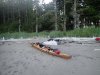
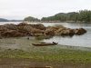
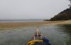
Last week I drove out from Prince George to Port Edward to paddle to and around Porcher Island. I drove to the public wharf in Port Edward and launched just after dinner time (note: there is a good food van parked here 5 days/week) and went between Ridley and Lelu Island and across to Kitson Island. I read somewhere that the camping area could be accessed from either the north or south but I could only find thick undergrowth on the N side so ended up paddling around to the south side (East end) to the camping area.
Kitson was the only place I camped that had roughly developed camping areas- there are flat sites in the trees, but no other facilities or water are available.
The idea was to try to use the ebb currents to advantage, so I was up at 5:15am and left on the falling tide just after 6. It was foggy to the south, and there were 8-10 commercial fishing boats active there in a small area S of Kitson. It seems like some crazy currents converge here (as well as being close to the mouth of the Skeena) and clearly there were a lot of fish here (many were jumping). Also the water was churning due to the local currents, which made the paddling a bit interesting. I had GPS'ed the Lawyer Islands for the crossing, which was useful in the fog. After an hour or so I was out of the fog and could see my waypoints across the channel.
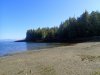
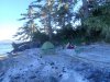
I reached McMicking Island and stopped at the first beach (N54° 03.425' W130° 17.861') to strip off the drysuit for 30mins (just N of the marked campsite in JKs Wild Coast 2).
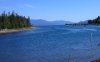
I then went in to the Chismore Passage and around to Oona River. The Harbour at Oona River is hidden by the breakwater but you can see a few houses from the water.
I stayed in a guest house in Oona River as there is nowhere to camp in the vicinity- check the notice board at the wharf, and there is a phone there too.
I left early the next morning, again hopefully to get a boost from the ebbing tide in the Ogden Channel, and also hoping for less wind than was forecast for later in the day. It was very foggy and the SE wind in the channel brought some difficult paddling in the waves, particularly as this section is mostly coastal cliffs, which would make retreat difficult. It was one of those days that I was glad to have the drysuit on. No photos from this stretch.
I reached much calmer water in the Gasboat Pass and looked for the campsite on Gilbert Island- pretty much the first beach available (N53° 49.211' W130° 21.531').
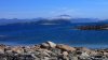
The paddling was much easier in among the Islands and I could soon spot Kitkatla. Also the fog and low cloud finally burned off, and it was a really beautiful day in a lovely location. The high peak visible below is Noble Mtn, which sits above the Petrel Channel.
The best camp I had was on high shell beach- not a lot of room, but there are not too many landing spots here and the forest is usually so thick that getting into the woods would be some work.
The idea was to paddle up the Kitkatla Channel into Kitkatlka Inlet JK makes a comment in his book about the difficulty of NW winds in this area, and I can attest to that. I had 3 days of pretty much non-stop NW winds. It was a bit lighter in the morning but in the end I had to turn around in the inlet as I could not commit to paddling out around to the N side of the island as the forecast was not too encouraging.
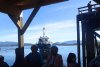
In the end I decided to take the water taxi out from Kitkatla. It only runs 2x per week so went out somewhat earlier than I had hoped. I paddled into Kitkatla and was able to wander around town (early on a Sunday) for awhile, and generally hand out on the dock waiting for the water taxi. The water taxi is a pretty big deal- lots of people suddenly arrived for the ride out.
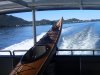
The incoming taxi had a lot of gear and groceries to unload. At first the "deck mate" was uncertain about letting me and my kayak onto the taxi, but I asked the skipper nicely and he pretty much didn't care as long as I could get it on. The ride out was only $23 (no gear/weight surcharge).,
The ride out took 2 hours to cover the same ground it took me 2 days to paddle.
Notes:
1. You cannot assume that you will be allowed to ride on the water taxi with your kayak and gear, especially on the ride out from Prince Rupert (this is the main way for the local to get goods and groceries so is often very full). The ride back to PR is more likely possible. You should call the North Co-Op ahead of your trip.
2. Camping is difficult, mainly using high beaches, so passing through here would be more tricky around New and Full Moon periods.
3. Water is also tricky to find. Many streams are basically inaccessible due to the rocky coast. Bring lots of water, a good filter pump system and refill when you can. Also the water in Oona River is truly awful.
4. On a sunny day the drive along the Skeena from Rupert to Terrace is truly spectacular- I have been to Rupert 4 times and this was the first time it was not rainy.
5. This would be a great place to bring a crab trap or fishing gear to.
6. Tides around here are big- can have over 6m change, and they were around 5m during my trip.
Kitson was the only place I camped that had roughly developed camping areas- there are flat sites in the trees, but no other facilities or water are available.
The idea was to try to use the ebb currents to advantage, so I was up at 5:15am and left on the falling tide just after 6. It was foggy to the south, and there were 8-10 commercial fishing boats active there in a small area S of Kitson. It seems like some crazy currents converge here (as well as being close to the mouth of the Skeena) and clearly there were a lot of fish here (many were jumping). Also the water was churning due to the local currents, which made the paddling a bit interesting. I had GPS'ed the Lawyer Islands for the crossing, which was useful in the fog. After an hour or so I was out of the fog and could see my waypoints across the channel.
I reached McMicking Island and stopped at the first beach (N54° 03.425' W130° 17.861') to strip off the drysuit for 30mins (just N of the marked campsite in JKs Wild Coast 2).
I then went in to the Chismore Passage and around to Oona River. The Harbour at Oona River is hidden by the breakwater but you can see a few houses from the water.
I stayed in a guest house in Oona River as there is nowhere to camp in the vicinity- check the notice board at the wharf, and there is a phone there too.
I left early the next morning, again hopefully to get a boost from the ebbing tide in the Ogden Channel, and also hoping for less wind than was forecast for later in the day. It was very foggy and the SE wind in the channel brought some difficult paddling in the waves, particularly as this section is mostly coastal cliffs, which would make retreat difficult. It was one of those days that I was glad to have the drysuit on. No photos from this stretch.
I reached much calmer water in the Gasboat Pass and looked for the campsite on Gilbert Island- pretty much the first beach available (N53° 49.211' W130° 21.531').
The paddling was much easier in among the Islands and I could soon spot Kitkatla. Also the fog and low cloud finally burned off, and it was a really beautiful day in a lovely location. The high peak visible below is Noble Mtn, which sits above the Petrel Channel.
The best camp I had was on high shell beach- not a lot of room, but there are not too many landing spots here and the forest is usually so thick that getting into the woods would be some work.
The idea was to paddle up the Kitkatla Channel into Kitkatlka Inlet JK makes a comment in his book about the difficulty of NW winds in this area, and I can attest to that. I had 3 days of pretty much non-stop NW winds. It was a bit lighter in the morning but in the end I had to turn around in the inlet as I could not commit to paddling out around to the N side of the island as the forecast was not too encouraging.
In the end I decided to take the water taxi out from Kitkatla. It only runs 2x per week so went out somewhat earlier than I had hoped. I paddled into Kitkatla and was able to wander around town (early on a Sunday) for awhile, and generally hand out on the dock waiting for the water taxi. The water taxi is a pretty big deal- lots of people suddenly arrived for the ride out.
The incoming taxi had a lot of gear and groceries to unload. At first the "deck mate" was uncertain about letting me and my kayak onto the taxi, but I asked the skipper nicely and he pretty much didn't care as long as I could get it on. The ride out was only $23 (no gear/weight surcharge).,
The ride out took 2 hours to cover the same ground it took me 2 days to paddle.
Notes:
1. You cannot assume that you will be allowed to ride on the water taxi with your kayak and gear, especially on the ride out from Prince Rupert (this is the main way for the local to get goods and groceries so is often very full). The ride back to PR is more likely possible. You should call the North Co-Op ahead of your trip.
2. Camping is difficult, mainly using high beaches, so passing through here would be more tricky around New and Full Moon periods.
3. Water is also tricky to find. Many streams are basically inaccessible due to the rocky coast. Bring lots of water, a good filter pump system and refill when you can. Also the water in Oona River is truly awful.
4. On a sunny day the drive along the Skeena from Rupert to Terrace is truly spectacular- I have been to Rupert 4 times and this was the first time it was not rainy.
5. This would be a great place to bring a crab trap or fishing gear to.
6. Tides around here are big- can have over 6m change, and they were around 5m during my trip.
Attachments
-
 1_Kitson_Island.jpg145.9 KB · Views: 2,194
 -
 2_Marcus_Passage.jpg90.3 KB · Views: 2,191
 -
 3_McMicking_Is.jpg151.4 KB · Views: 2,204
 -
 4_Oona_Hbr.jpg81.5 KB · Views: 2,198
 -
 5_Gilbert_Is.jpg159.8 KB · Views: 2,207
 -
 6_Near_Kitkatla.jpg83.5 KB · Views: 2,195
 -
 7_Camp_3.jpg211.1 KB · Views: 2,210
 -
 8_Billy_Bay.jpg80.2 KB · Views: 2,186
 -
 9_Kitkatla_Tombolo.jpg72.2 KB · Views: 2,192
 -
 10_Water_Taxi.jpg67.8 KB · Views: 2,182
 -
 11_Ride_Home.jpg123.5 KB · Views: 2,232
