• We apologize for the somewhat convoluted sign-up process. Due to ever-more sophisticated attacks by chatbots, we had to increase our filtering in order to weed out AI while letting humans through. It's a nuisance, but a necessary one in order to keep the level of discourse on the forums authentic and useful. From the actual humans using WCP, thanks for your understanding!

Testing out Windy

AM

Paddler
Joined
Jan 30, 2006
Messages
1,146
Location
Vancouver
In a recent trip report, Alex talked about how he uses Windy to plan his trips, including crossings. I was interested in this strategy, but I had no experience with the Windy app. I decided to keep an eye on some local areas this fall/winter and compare the weather station readings with Windy.

What I found so far is that Windy is good for large-scale predictions, but inaccurate for areas affected by local considerations, as the two models that work in our BC waters, GFS and ECMWF, are global and low-resolution. Supposedly, ECMWF takes into account more local features, but I found that GFS is more accurate at the locations I followed.

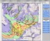
Here are three areas I have been watching. The graphs are taken from the Fish Weather app, which collects data from the weather stations. The Windy readings for ECMWF are in my handwriting in red. The GFS readings are green.

1. Solander: the Brooks Peninsula is well known for strong winds, especially on SE blows. Windy fails to predict these large SE winds, as the following graph shows. You can see that Windy’s ECMWF predictions underestimate wind speed by up to 15 knots on this occasion. The biggest difference I’ve seen was on November 16, 2019, when Solander station registered SE 53 knots, whereas Windy had it at SE 27. By contrast, the GFS model is more in the ballpark, but still not super accurate.

B3165F88-7C9C-4020-B82E-A4ABF9C49886.jpeg


2. Sisters Islet

Sisters Islet station often registers the biggest SE winds in the Strait of Georgia. Again, Windy’s ECMWF model fails to register the strength of these winds accurately, with up to a 15 knot discrepancy. GFS is more in the ballpark.

43C87BD9-B330-42A4-B6A4-3329E8CDA30E.jpeg

3. Pam Rocks (Howe Sound)

Pam Rocks is an interesting case. In the summer, this area sees pretty regular daily patterns of inflow/outflow. In the winter, there can be arctic outflows of considerable strength. Neither of model predicts these northerly winds very well. In today’s wind event, it even got the direction wrong, predicting wins E or SE winds up to 10 knots, where the station registered N winds of up to 15 knots.

CDB5389A-04B1-4DE4-A89E-2FCB7DC27C63.jpeg


My summary: of the two models, choose GFS for local waters. Even then, areas with known local effects will not be accurately represented, so local knowledge and the shared experience of mariners is essential. Of course, I’ll have to run these comparisons in the summer when different weather patterns prevail.

Cheers,
Andrew
 
Good read and interesting comparison. Please carry on with this experiment and continue to post your results!

I'm curious what other people are using for their go-to forecasting needs. Are apps like Windy superior to the Environment Canada or NOAA marine weather forecasts? These apps provide a nice visual representation for your smartphone but are they not just drawing on existing reports (weather stations, lighthouses, etc)? In my 20 years as a mariner the VHF weather report was the first thing we listened to in the morning and the last thing we'd hear before turning in, and I couldn't imagine using anything else....of course, that may very well be an old school way of thinking ;) as smart phones did not exist and dinosaurs still walked the earth. Your own point above re: Solander Island (a notorious blowhole) is a good example - SE 27 knots (based on a model?) versus actual reported speed of SE 53....big difference :eek:

It's interesting how weather reports/apps are perceived by the community; case in point: last summer I was on a west coast expedition with a local outfitter.
What I found so far is that Windy is good for large-scale predictions, but inaccurate for areas affected by local considerations, as the two models that work in our BC waters, GFS and ECMWF, are global and low-resolution.
My experience on this trip was the exact opposite; it was inferred that the Environment Canada marine weather forecast was a good 'guideline' but Windy was a much better tool for predicting specific, local conditions. I did not agree with this assessment.

FYI - Forbes has an interesting read on relative accuracy of the ECMWF (European) versus GFS (North American) forecasting model here
 
I'm curious what other people are using for their go-to forecasting needs.
I'm not a 'big phone user', and often on trips I'm out of cell range. I haven't jumped to inReach (yet), so sat communications for weather aren't an option for me. So it's pretty much the VHF marine forecast for me.

For trip planning or day paddling when I am at home, I use EnvironmentCanada marine forecast, but mostly Predict Wind. Checking the buoy/lighthouse/weather station current conditions just before leaving the house has been useful at times, too.
Predict Wind seems quite accurate, and around Victoria the 1km resolution forecasts are available for a couple of days in the future. Other areas and forecasts for more than a couple of days in the future, it's 8 km or 50km resolution. PW uses several models and I can choose which ones to use in the side-by-side display.
The different models used in Predict Wind are described at their website:
PWG stands for the PredictWind weather model that uses the NCEP global initial conditions for the model run and PWE is the PredictWind weather model that uses the ECMWF global initial conditions, both of these sources enable us to run our own worldwide weather models, we are the only company in the world that produces these forecasts.

In addition we also provide the GFS (Global Forecast System) from NCEP as this is used by most other weather websites/apps as well as the ECMWF forecast from ECMWF (European Center for Medium-Range Weather Forecasts) that is highly regarded by Meteorologists and top Navigators around the world.

Comparing the PWG/PWE forecasts allows you to gauge the confidence level in the forecast, and adding the GFS/ECMWF forecasts takes your confidence to a new level. Generally the unique PredictWind model, and its higher resolution will be more accurate, but with all 4 forecasts you can have greater confidence in your forecast to make the best decision.

It's interesting to compare the models side-by-side. When I look 'farther in the future', sometimes the different models are making quite different predictions. This is usually a 'watch out' sign for me.

upload_2020-1-4_10-24-24.png


This agrees with my experience with weather forecasts in general - usually we get the weather that's predicted (more-or-less) but the timing is often inaccurate.

I haven't used Windy at all. Sorry if this post is too far off-topic!
 
John, thanks for the PW tip. I will definitely check it out.

My experience on this trip was the exact opposite; it was inferred that the Environment Canada marine weather forecast was a good 'guideline' but Windy was a much better tool for predicting specific, local conditions. I did not agree with this assessment.

Thanks for that detail. I know that our frustration with Environment Canada predictions is that they cover such a wide area and, on the west coast, are talking about maximum winds well offshore. Maybe that’s why the outfitter liked Windy. Also, I’m wondering if regular summer patterns of high pressure create more predictable winds that are less affected by the Coriolis Effect. What sets off Solander are these big low pressure systems.

At any rate, more watching is required. But at the end of the day, my VHF is still my most valuable all-round device, both for its weather forecasts and communication abilities. And I still like the fact that local knowledge can tell us things that our devices can’t. We aren’t obsolete quite yet!

Cheers,
Andrew
 
I've probably posted it before, but change has to start somewhere. It would be much handier if that area the broadcast covered were more clearly defined. I often hear, "What area are we supposed to listen for?". I believe it is "inland waters" but that's a pretty wide area. I like the idea of recording the broadcast so it can be played back without using battery on an emergency device (VHF radio), but that's one more thing to pack, one more set of battery conditions to keep track of.

Essentially I check the websites (NOAA, Weather Channel, etc.) before I leave home. I listen to the VHF broadcast at launch points and each day while on adventure. But mostly I use my eyes to see what's happening out there.

Have to admit I was pretty impressed when the VHF said rain would come about 2 pm (Orcas Island) and I used that to determine a window to paddle back from Patos. As I was unloading at North Beach, about 1:55pm, it started to sprinkle (developing into RAIN). Pretty darn good - that day.
 
Andrew, thanks for starting this very interesting thread. My experience with Windy has been that it is accurate at large scales, but not as accurate at local scales as the zone-specific government forecasts, including the VHF marine broadcasts. I mainly use Windy to watch for mesoscale weather systems. That, plus the government's wide area forecast discussion, gives me the background I need to understand the local, zone-specific forecasts, ie, why the local forecast is what it is. Windy gives you the illusion of extremely localized forecasts (down to tens of meters), but in reality, it is only a large-scale tool, for the reasons you note.

In terms of the zone-specific forecasts, we are lucky in Washington to have very small forecast zones. Other than the Straits of George and Juan de Fuca, Environment Canada's zones cover 5 to 10 times the area of the Washington zones, leading to the problem Andrew describes of forecasts for West Coast Vancouver Island, where the "local" forecast includes winds a hundred miles offshore.

See below for comparison:

00 WA map.jpg


00 BC map.jpg


Alex
 
Interesting discussion. I never realized there was such a great difference in forecast areas between Canada and the US. I have never felt undersupplied with overall forecast information on Canadian waters, but I've only paddled in a few areas: Barkley Sound, Clayoquot Sound, the Gulf Islands, the east side of Moresby in the Charlottes, plus lesser forays in the Broughtons and the N and E shorelines of Nootka Island.

The daily dump of forecast info from Environment Canada on the VHF pretty much determines my mode for the day, although it screams so rapidly by my flawed hearing and cranial microprocessor I need two passes..

When unsettled weather, major front(s), or significant winds are in the mix, I make a point of picking off lighthouse and buoy reports on the fly, up-weather system from my location, mentally tracking the two lighthouse reports on either side of my location. Usually, if entering or leaving a protected area, the barometric pressure trend and changes in wind speed and direction are enough. If this sounds sketchy, about all I can offer is that it worked for many years, through 2010.

We ran exposed points of the "highway" frequented by paddlers along the east side of Moresby, three different summers, and the exposed waters in the Houston Stewart Channel area out to Ninstints twice, much of this in sketchy weather, dodging smaller fronts as they washed through, making use of the intervals of lesser winds to hop from campsite to campsite. The latter area has a buoy up-system on the SW side, and one down-system on the SE exposure, each providing wind and pressure information. The HSC area buoys were especially reliable in tracking micropresssure changes indicative of front arrival and exit. Two or three times we packed our boats up in the morning and plonked our butts on logs, under a tarp, launching on the first uptick of pressure, usually forenoon, and skedaddled around an exposed area in the "good" weather window.

This is a full-on weather-geekoid approach, for sure! But we had fun with it. I avoided KP duty several nights when it worked. And got slammed with cook and bottlewasher chores when it didn't!
 
Okay, this demonstrates the local effect that the weather models do not predict. With this arctic air mass bringing freezing temperatures to coastal BC, all the local mariners know that outflow winds will be huge in the inlets. None of the models mentioned above predict this effect. See these screenshots: GFS predicts NE 3 kts, but the weather station has been reading high 30s (gusting into the 40s) all day.

1A44980E-B29B-4C65-8A83-07FBEEAFDDA1.png
3960B817-3AC5-4D16-AAA5-1AF37694212A.jpeg
 
Well, since you asked, here is what we have just before 0700 this morning:

ECMWF: N 6
GSF: N 7

And Pam Rocks is measuring the actual wind at...N 45

Here’s the explanation from Lange in The Wind Came all Ways. Today’s pressure gradient is very similar to the one described in the example below and Windy does show the isobars, so you can make a good guesstimate by that alone:

67920339-185F-4661-AB84-5B6F9B9B8470.jpeg
 

Attachments

  • 4BD1A8A9-256A-4022-8CAE-3C556B97EB84.jpeg
    4BD1A8A9-256A-4022-8CAE-3C556B97EB84.jpeg
    419 KB · Views: 253
Well, the outflow is easing off. Cathedral Point near Bella Coola was a really interesting example of local effects. The models had predictions of NE/E 9 to 11 knots all night. The actual wind speed was at hurricane levels from yesterday afternoon till this morning.

80B1C079-751F-46DE-9E50-CCC88B477BBB.jpeg
 
I'm trying to keep an open mind on this but....

This just reinforces my view that these apps are not reliable and should be treated as such. How can a weather model that disregards regular, known - known! - wind speeds and conditions (lighthouse and ocean buoy reports) even be considered a reliable predictive model?

Granted, the examples posted above might be extreme but still.....50 knot outflow winds through mainland inlets (Pam rocks, Cathedral Point) are known entities and easy to predict - unless you're Windy :confused:. Not that any of us on here would ever do it ;), but if you didn't know any better and just went by your app, this could literally be life-altering stuff.

I recognize that the responsible and safety-conscious folks on here will use (and weigh accordingly) all methods available, but I can't help but think this is part of the 'dumbing down' of society in general. Going boating? There's an app for that :rolleyes:

Am I wrong?
 
What was the EnvCanada Marine forecast for those times and locations?
Would the VHF forecast (not buoy/lighthouse reports) have been any better?
I don't know how to get past forecast data.
 
They were forecasting hurricane force winds for Howe Sound. I didn't look elsewhere.
Past forecasts might be interesting. Wayback machine or something like that maybe?
 
Back
Top